こんなことを考えています
森林のことを知ろうとするとき考えなくてはならないのは、森林は長い歴史を持っているということです。さらに、その森林はそれだけで存在しているのではなく、周囲の状況(物理的にも制度的にも)が影響を与えた結果として存在しています。つまり、現在の森林だけではなく、その森林がどのような変遷をたどってきたかを、その森林の周囲の状況を考え合わせながら見てゆく必要があります。
ところが森林は広大です(農地だって都市域だって広いのですが、森林はもっと広くて行きにくい場所にたくさんあります)。 もちろん現地に自分で行って森林を五感で体験し詳しく調べることが一番大切です。でも一人(数人のグループでもかまいませんが)で調べることのできるのは、広い森林に比べるとほんのわずかな点に過ぎません。
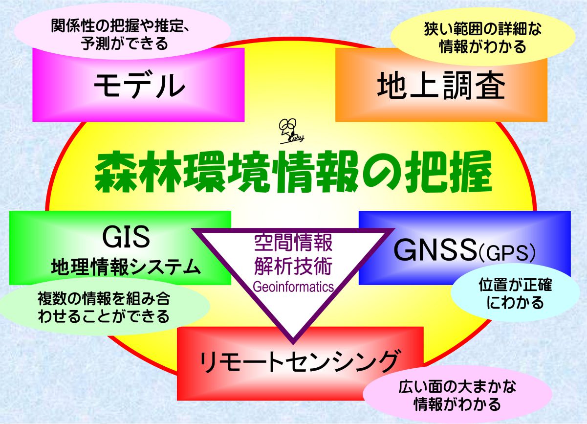
ですから、自分自身で調べた点が広い森林(地域)の中でどの部分に属しどの程度の代表性を持っているのかは、いつでも意識しておく必要があります。そんなに詳しくなくてもよいから丸ごと知りたい!という場合には、リモートセンシング(RS)技術を使って、面として森林とその周辺のようすを一度に調べることができます。そして現地調査の点とRSの面を結ぶのはGNSSであり、GIS(地理情報システム)です。RSもGISもGNSSも空間情報解析技術と呼ばれたりしていますが、どれも空間情報を扱う技術です。
森林と人間がこれからも共存してゆくために、これらの空間情報処理技術を道具としてどのように役立ててゆくことができるかを考えていきたいと思っています。
こんなことをやっています
ひと言で言えば、「空間情報解析技術を利用した森林・緑地環境の把握」ということになりますが、もう少し具体的に言えば、
・リモートセンシングとGISを利用した森林環境評価法の開発
・衛星リモートセンシングによる森林環境モニタリング
・森林におけるGNSS利用
・REDD+に対応したアジア地域熱帯林計測技術の開発
・ディジタル空中写真を利用した森林景観構造の把握
といった内容です。これまでは東南アジアや日本が主な研究対象地でしたが、最近になってシベリアの森林も対象地に加わることになりました。
森林環境の把握のためには上の図のような5つのツールを主に使います。それぞれのツールには得意不得意があるので、研究対象や目的に応じて、いかにうまく組み合わせて使いこなすかが重要です。たとえば、リモートセンシングデータを利用すれば現地に行かなくてもよいかと言えば、まったくそのようなことはありません。少なくともリモートセンシング画像を見れば現地の森林がどのようなようすをしているかを想像できるようになるくらいになるまでその土地のことを知っておく必要があるので、現地観察は必要不可欠で重要なステップです。森林バイオマス推定や森林構造の把握が目的であれば、森林内にプロットを設けて毎木調査を行うことが必要な場合があります。そのためには、森林プロット調査の技術が必要です。また、海外の森林を対象としたケースでは、私たち日本人だけで調査はできないので、現地の研究者などと協力して行うことになります。その際には、英語(やできれば現地語)でのコミュニケーションが欠かせません。それぞれのツールを使いこなすためには、単なるツールのユーザとなるのではなく、バックグラウンドとなる学問分野や技術についての知識を持つことが重要です。学生の皆さんには、宇宙工学から森林生態系まで、必要に応じて学んでほしいと思っています。
コンタクト
露木 聡 教授・農学博士
東京大学 大学院農学生命科学研究科 農学国際専攻
国際森林環境学研究室
〒113-8657 東京都文京区弥生1-1-1
Tel: 03-5841-7509
Fax: 03-5841-5235
email: tsuyuki (at) fr.a.u-tokyo.ac.jp
What am I thinking....
When we want to know about any particular forest, what we have to be aware
of is, any forest has its own history. Moreover, the forest does not exist
alone, but it exist as a result of influences from its surrounding situation
(both physically and institutionally). That means, we have to think of
how the forest had been changing, also with its surrounding conditions,
to know the forest.
But forest area is very large. (Of course agricultural area and even urban area are also large, but forest is even larger and usually exists in inaccessible place.) Most important thing is to go the forest by yourself, feel forest by your whole senses and make detailed field research of the area. But what you (or your group) can see is only limited points of the large forest area.
So, we always have to be aware of which part of large forest area does
our field research points belong to, as well as their representativeness.
If you want to know about whole forest and its surrounding area, but not
so much in detail, we can use "remote sensing(RS)" technique
to know as an area at once. To connect the detailed field research points
and the information of the area obtained by RS, we can use GIS (Geographic
Information System) and GNSS.
These technologies are called "Geoinformatics" recently, all
of them are dealing with geo-spatial information.
I hope I can keep studying how to use these spatial information processing
technologies effectively as tools to help forest and human being live together
long.
In short, my researches are on forest environmental analysis using geo-informatics such as ;
・Development of forest environmental assessment method using remote sensing and GIS
・Monitoring forest environment using satellite remote sensing
・GNSS utilization in forest area
・Development of Asian tropical forest mensuration method applicable to REDD+
・Application of LiDAR and aerial photographs for reconstruction of 3D forest structure
・Forest disturbance assessment in Siberian nature reserve area.
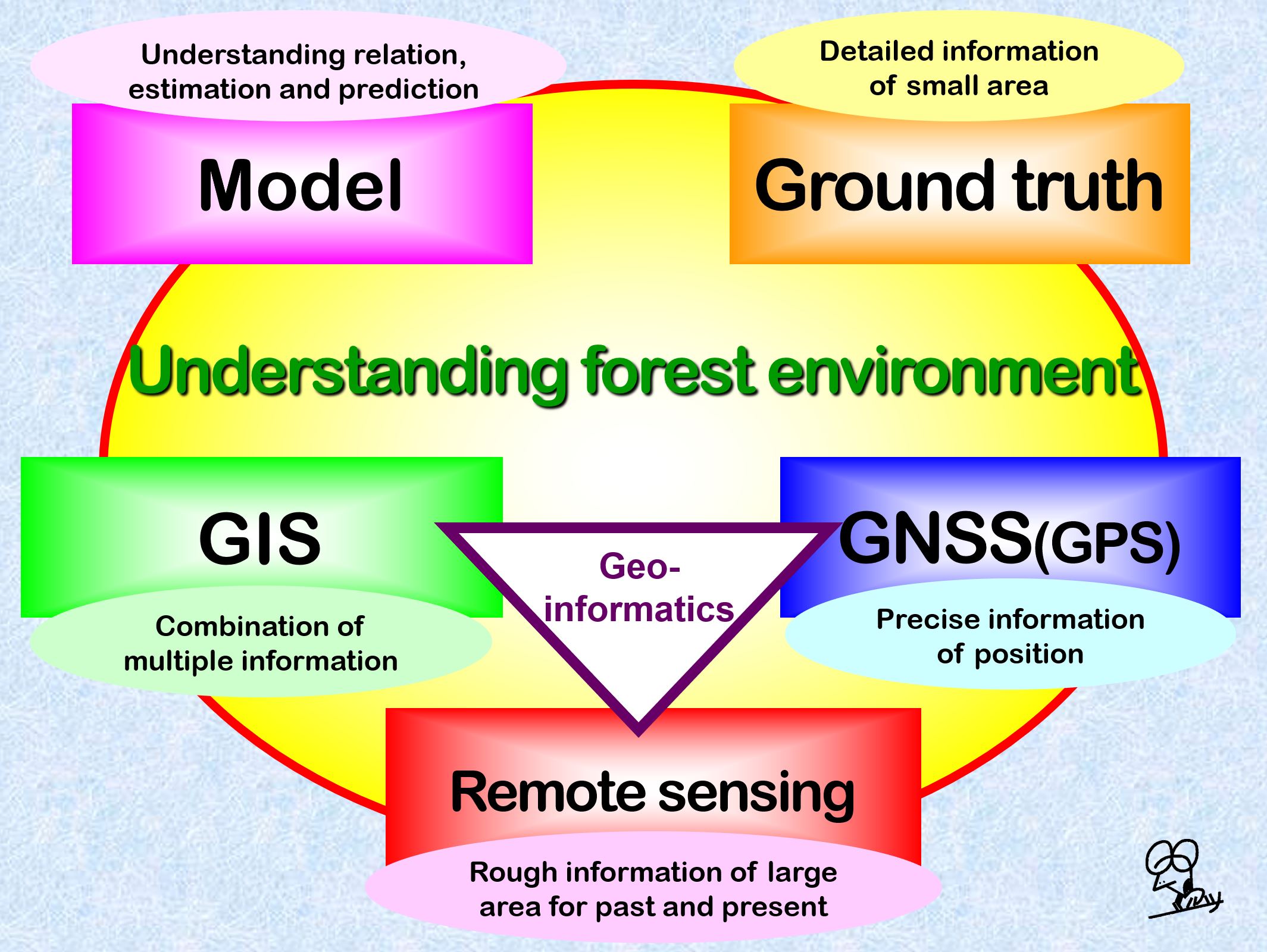
Basically, five tools shown in the upper figure are used to conduct there
researches. As each tool has its own strong points and weak points, we
have to select and combine those tools according to the research objective.
But to use the tool, fundamental knowledge of its background are indispensable.
So, I want my students to learn from space technology to forest ecology
when necessary.
Contact
Satoshi TSUYUKI, Professor
Lab of Global Forest Environmental Studies,
Department of Global Agricultural Sciences,
Graduate School of Agriculture and Life Sciences,
The University of Tokyo
1-1-1 Yayoi, Bunkyo-ku, Tokyo 113-8657, Japan
Tel:+81-3-5841-7509, Fax:+81-3-5841-5235
email: tsuyuki (at) fr.a.u-tokyo.ac.jp
Satoshi TSUYUKI (Professor, PhD)