
RS/GISゼミ 修士論文、博士論文のテーマ (◎:海外、●:国内)
MSc and PhD theses of RS/GIS semi (◎: overseas, ● : domestic)
D2023◎ Combined application of machine learning with multi-source remote sensing data for
forest type classification and carbon stock estimation
(機械学習とマルチソースリモートセンシングデータの森林タイプ分類と炭素蓄積量推定への適用)
<Pei Huiqing>
D2023● 低密度LiDARによる効率的な森林資源情報の把握に関する研究
<小谷 英司>
D2023◎ Assessing the Impact of Tobacco Production on Forest Landscapes in Hurungwe District, Zimbabwe
(ジンバブエ・フルングウェ地区におけるタバコ生産の森林景観への影響評価)
<Spencer Sibanda>
M2021◎ Spatial time-series analysis of the impacts of Urban Expansion on Forest Areas in
Manaus city, Brazil
<Danielle Nogueira Lopes>
M2021◎ Forest cover change over 24 years in the North and South Pare Mountains, Tanzania
<McClure Mary Margaret>
M2021● Locating Windthrown Area in the University of Tokyo Chiba Forest Using Aerial Photos
<Li Yanbo>
D2021◎ Assessing Impacts of Human Disturbance and Fire on Forests in the Protected Area of
Russian Far East using Remote Sensing Data
<Khatancharoen Chulabush>
D2021● Survival analysis of individual tree populations in natural forest stands: A case study
of preserved forests in the University of Tokyo Hokkaido Forest, northern Japan
<Wijenayake Pavithra Rangani>
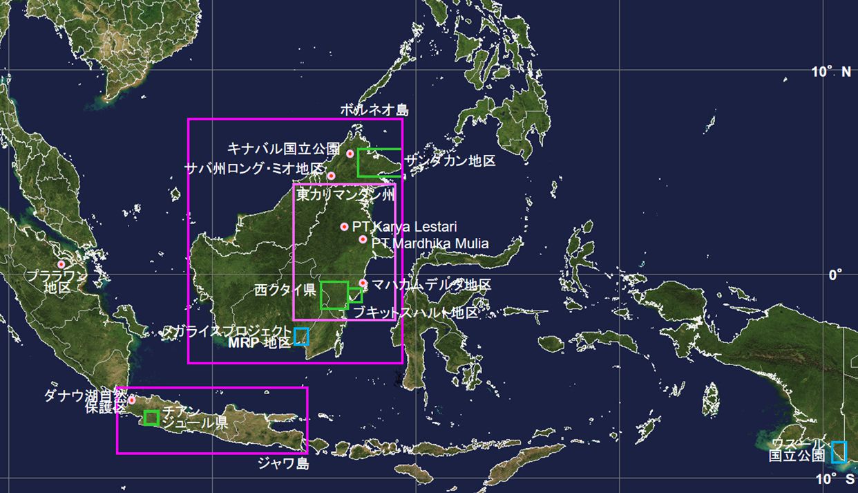
D2020◎ ボルネオの開発過程における社会階層の動態 —ムダン人コミュニティのリーダーシップ論—
<藤原江美子>
M2019◎ Understanding the role of Community Forests for Earthquake resilience in Nepal,
a remote sensing approach
<Angel Adhikari>
M2019◎ Estimating above-ground biomass of tropical montane forest in Malaysia Borneo using
Sentinel imagery
<天沼絵理>
M2019● Detection of Japanese Oak Wilt damaged trees in The University of Tokyo Chiba Forest
using RGB color aerial imageries
<Yueren Wu>
D2019◎ 内/外関係にみる現代台湾漢人農村の社会関係 ―非近郊平場農村の事例から
<前野清太朗>
D2019◎ 国際協力事業における『誘導型ファシリテーション』の役割
-インドネシア泥炭火災予防プロジェクトの事例から-
<新井雄喜>
D2018● 航空レーザ計測による単木資源情報の把握に関する研究
<大野勝正>
D2018◎ Use of medium-resolution satellite remote sensing data to estimate above-ground biomass in
Buffer zone community forest of Nepal
<Santa Pandit>
D2018◎ Landscape Strategies of Forest Restoration and Management to Reduce GHG Emissions Using
Time-Series Land Cover Maps in East Kalimantan, Indonesia
<Kiswanto>
D2018● Applicability of unmanned aerial vehicles (UAVs) for uneven-aged forest management planning:
A study in a mixed conifer-broadleaf forest in Norhtern Japan
<Sadeepa Jayathunga>
M2018● Estimation of tree height from single tree detection using small-footprint airborne LiDAR
and aerial photography in a coniferous plantation forest in Saitama, Japan
<Dilibaier Tayier>
M2017◎ Object-based Forest Cover Change Mapping Using Remote Sensing in Nuristan Province,
Afghanistan
<Shogufa Popal>
M2017◎ Evaluating Fire Disturbances and Forest Cover Changes Using Remote Sensing in Zeya
State Nature Reserve, Russia
<Chulabush Khatancharoen>
D2015◎ Optimizing digital aerial photogrammetry for forestry applications in tropical montane forest
environment
<Wilson Wong Vun Chiong>
M2015◎ Analysis of structural complexity using airborne LiDAR and aerial photography in a mixed
conifer-broadleaved forest in central Hokkaido, Japan
<Sadeepa Jayathunga>
M2015◎ Spectral mixture analysis of Landsat satellite imagery for land cover study of highly degraded
peatland in Indonesia
<Anjar Dimara Sakti>
D2017◎ Geostatistical method for supporting sustainable forest management in East and North
Kalimantan, Indonesia
<Ali Suhardiman>
D2014◎ メコン中下流域におけるリモートセンシングを用いた森林変動モニタリング手法に関する研究
<古屋直行>
M2012◎ 中解像度衛星リモートセンシング画像を用いたオブジェクト指向分類によるマレーシア・サバ州
熱帯林における森林タイプ別バイオマス量の推定
<星元啓吾>
M2011◎ インドネシア東カリマンタン州におけるフタバガキ科樹木の生育地推定に関する研究
<青柳弘太>
M2010◎ Comparison of land cover and forest plantation classification ability using Landsat TM and
ALOS PALSAR – Case study in Pelalawan, Riau Province, Indonesia
<Anny Meilani>
M2010◎ Mapping prone area occupied by Melaleuca sp. using remote sensing: Case study in Wasur
National Park, Papua, Indonesia
<Ignatius Chirstianto Ginting>
D2008◎ Understanding spatiotemporal patterns, processes and causes of land-use and land-cover
change (LULCC) in the tropical environment
<Arief Darmawan>
D2008● 高精細リモートセンシングによる林分構造の把握に関する研究
<平田泰雅>
M2007◎ 衛星リモートセンシングとGISを用いた裸地化傾向の把握 –インドネシア西クタイ県を事例
として-
<髙橋健太郎>
D2007◎ GIS-based modelling of Javan-Hawk-Eagle (Spizaetus bartelsi) habitat distribution using
multi-scale approach in Java Island, Indonesia
<Syartinilia>
M2006◎ オイルパームプランテーション面積推移の推定における階層的分類の有用性
<矢野圭一>
M2005◎ Estimating aboveground teak plantation forest biomass using remotely sensed data in
Cianjur, Indonesia
<Arief Darmawan>
D2004◎ Study on forest degradation dynamics of Borneo tropical rain forest based on historical land
cover change analysis using remote sensing
<Muryanto Darmawan>
D2004◎ Estimation of Global NPP Based on the MODIS 17 Algorithm
<橋本博文>
M2004◎ Landsat dataを用いたマレーシアにおけるオイルパームプランテーション面積の経年変化解析
<三宅麻利江>
M2004● 京都議定書第三条三項対象林分の算定における既存情報の精度検証 –行政情報、空中写真、
衛星情報を用いた検討-
<結城仁美>
M2002◎ Landsat TMを用いたチーク林の判別と分布特性 –インドネシア西ジャワ チアンジュール県を
事例に-
<加藤顕>
M2001◎ 衛星リモートセンシングを用いた東南アジアにおける森林火災後の広域植生モニタリング
<加藤知彦>
M2000◎ 衛星リモートセンシングデータを利用した土地利用変化の把握 –インドネシア ダナウ川を
事例として-
<馬場亜希>
M1999◎ 衛星リモートセンシングデータを利用したインドネシア森林火災の被害評価
<山口綱士>
M1998● 衛星リモートセンシングデータを利用した森林風倒被害地解析技術の開発
<村上正泰>